Click here for
San Juan Itinerary
San Juan Islands Cruise Guide
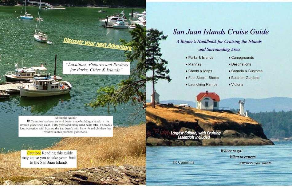
This is the Front and Back cover of the printed guidebook "San Juan Islands Cruise Guide"

San Juan Island Cruise Guidebook - book
You can take a look around this site, its unfinished, but then go to http://www.sailingthesanjuans.com/ to see in depth San Juan information. You may see about ordering the guide book above
it's gone to press and ready to ship overnight from Amazon.
Not Just A Beginner's Guide to Boating the San Juan's
This guide will lead you step by step to that first San Juan cruise. Everything you need from provisioning to basic boating tips. And most importantly, where to go and how to get there.
Here is some of what's waiting for you inside.
- complete list of islands and destinations to visit
- campgrounds, anchorages, and docks for overnight stays
- maps and charts
- launching ramps and trailer parking
- resorts, marinas, parks, city's
- fuel stops, stores, provisioning
- rules and regulations,
- Canada, customs, Victoria, Butchart Garden
- suggested itinerary's - day trips - overnighters - one week and longer
- helpful tips to guarantee an awesome cruise (mistakes and pitfalls to avoid)
- packing and provisioning check lists
- Much more Tips (even dinghy tips)
Before ever going boating in the San Juans, I thought about it a lot. Whats the right boat? Where will we put in, and park the car? Where will we go, spend the night, get gas? What about the horrible currents, Deception Pass and whirlpools? Was it foolish, reckless, or endangering my family? The list of questions was endless and it was a little scary making that first big step. Eventually we cast off our mooring lines, and so can you. Inside you will find detailed descriptions of places to visit, and worthwhile things to see and do.
You will find useful, and helpful information, not candy coated flowery descriptions written to sell you something.
I have tried to share our knowledge, so that others, especially budget conscious trailer boaters dragging along family's can head for the San Juans with confidence. Sadly, many readers will not actually be able to visit the places I write about, so I try to keep articles entertaining and include many pictures.
 |
Friday Harbor is the center of the San Juans and your number one destination choice. Tip If you have only one day (or part day), and are going to only one place, you should go to Friday Harbor. |
On the right side bar is a table of contents, and a very useful resource list. You may also use the search box to find exactly what you want.
This guide is organized to introduce you to the areas launching points first, then some pictures to hint at whats to come, followed by all the destinations of note. Next are planning helpers, single and multi-day itineraries and suggestions. There are special chapters devoted to Canada / USA customs, currents, weather, safety, and lots of tips to make the most of your cruises to this very special area.Sailing the San Juans
Chapter # 1
Get oriented and Launch the Boat
At first this map/chart may look strange and unfamiliar, but soon these names and places will become a source of fond memory's. Take a moment to study the names. As you learn more about the San Juan area, you may want to come back to this page to keep oriented. I suggest that you locate Bellingham, Anacortes, La Conner, and Friday Harbor. These four city's will be central in your San Juan experience if you come back again and again like we have. (click on the image, see if it gets bigger)
 |
| Red dots are Parks, Green dots are Floats (docks), Purple dots are Ramps |
Tip Squalicum Harbor in Bellingham is by far the best ramp and facility around, and has my highest recommendation. If your planning to go to Sucia for the first night, you should start at Squalicum Harbor.
- Four lanes, suitable at all tide levels, open 24/7
- Lots of free parking, long or short term (this is a $100+ savings)
- Fresh water wash down hoses (always wash your trailer immediately after immersion)
- On site restaurants, and bathrooms with showers.
- Transient boat docks for overnight visits
- Major stores near by, but not walking distance
- Closest jump off point to Sucia, Matia and Patos Islands
- Fuel dock, pump out
Next on the list of popular launching points is Cap Sante in Anacortes
- Two Sling launches (big and little) but no Ramp (keeping your trailer out of salt water is a good thing) may require reservation or waiting in line, not 24/7 use
- Fee parking, long term, short term (rv parking too) fees add up fast
- Restaurants, bathrooms, showers
- Transient boat docks for overnight visits
- A few major stores near by (Safeway is across street)
- Fuel dock, pump out
- Closest to Friday Harbor and inner island area
Not very far, but overlooked is La Conner on the Swinomish Channel
- big and little travel lifts (sling) at several marinas (may need reservations)
- one lane public city ramp with float, 24/7 use, all tides except minus
- inexpensive, limited parking at ramp but pay parking at marinas
- transient docks for overnights at marina and along city seawall (really nice stopover place for lunch or the night at three city floats) Tip you really should visit La Conner by boat or car
- quaint restaurants, quite a few, all walking distance
- no name brand major stores but a very well stocked local store is a short walk, and they have block ice too (open pretty late too)
- fuel and pump outs
- closest to Deception Pass and heading south to Puget Sound area
- La Conner has been our home base where we moor the boat for summers now for several years. They have lots of slips available, unlike Cap Sante and Squalicum.
Best kept secret is Cornet Bay at Deception Pass State Park
Cornet Bay is my second ramp choice, and I use it if my plans call for easy access to the southern area, and most importantly long term hassle free parking and 24/7 usage. Tip Great place to spend several days hanging on your anchor or at the dock when Rosario strait is foggy.
Cornet Bay is my second ramp choice, and I use it if my plans call for easy access to the southern area, and most importantly long term hassle free parking and 24/7 usage. Tip Great place to spend several days hanging on your anchor or at the dock when Rosario strait is foggy.
- four lane all tides ramps and floats
- lots of long term fee parking ($10+ day)
- transient floats .60/ft
- small convenience store, short walk
- hiking trails
- small bathroom
- to get to the San Juans, you have the option of going through nearby Deception Pass or using Swinomish channel to avoid weather issues.
- on shore campgrounds
Washington Park in Anacortes, City park (campground) with ramp
- two lane ramp, and float
- limited fee parking, but long term, was $8 day
- subject to wakes
- bathrooms
- no overnight boat tie up, but you could anchor out
- on shore campground, would make good home base for day only boating
- just a few miles to stores in town
- absolute closest jump off point to San Juans
Twin Bridges Ramp at north end of Swinomish Channel (I have used once, I didn't like it)
- two lane county ramp with float
- strong current a lot of the time
- shallow at low tide
- horrible stinky bathroom
- questionable security in long term fee parking lot
- no stores
- no transient tie up
Oak Harbor
- ramp and travel lift
- long term parking
- stores are a few mile drive
- really not needed, other ramps are closer
- fuel and pump out
All of the San Juan Islands have county, resort, and marina boat ramps, but I have left them out because in all likelihood you will not be taking your boat and trailer on a ferry when going cruising. Never the less there are vacationers that rent houses and bring their boats with them for day outings and will find this guide equally useful.
The map below is much the same, but with many more names marked, and it's bigger so you can more easily read them. As you use this guide, come back here and find new places mentioned.
 |
| Scroll this picture if it is off your screen, clicking makes it smaller. |
Chapter # 2
Orcas Island Group
When planning your cruise keep in mind that you can't see and visit everything you have ever read or heard about in one day. You will have to pick and choose your destinations, and come back again one day soon. Some choices make logical sense, such as planning a circular route to reduce distance. Another good idea is to Tip plan an ice or provisioning stop three of four days into the cruise.
The Orcas Island Group includes:

 Shuffle Board at Rosario
Rosario once was a private residence, and the original mansion is now used as a museum and restaurant. When visiting don't be surprised to see large groups attending weddings and other events. The natural bay has been turned into a small marina with rental slips, and anchor buoys off shore. The anchor buoys and the free open anchoring area are open to the sound, the marina slips are not, nuff said? (hint -- open to the sound means, open to wakes and waves) On the float is a fuel dock, nestled on the manicured lawns are tame deer, a cafe and small grocery and gift store. Stop for an hour a day or overnight Visiting Rosario is the one place your friends will ask you about, it seems to have developed a mystique that has traveled to non boaters.
Rosario resort is much talked about and highly touted as the place to go of all places. My perspective is somewhat different.
First of all, yes you should go there and tour the mansion and free museum if you have any interest at all in the areas history.
Secondly there is nothing at all wrong with their store, fuel dock, restaurants, or marina slips. Very tame pet-able deer wander the spacious grounds and so do we when we visit.
Rosario is located part way in on the right side of East Sound, just a rock skip past the community of Olga. On shore you will find a well stocked store with slightly elevated prices, but after all it's Rosario don't cha know. The large two sided fuel dock is easy to get in and out of regardless of wind direction. The staff is very friendly and once let us leave the boat at the main dock, (we just pushed it past the fuel area) while we bicycled three hours to Moran State Park. They won all the points that day. Tip Rosario is one of those places you have to visit sooner or later to be a complete San Juan cruiser.
There is no fuel, nor is there a suitable place to bring your dinghy ashore, except out on the point where the county built a public dock and small float. You can tie up and walk to town where you will find a large full service grocery store that everyone on the island uses. The walk is a short two blocks. Your not supposed to over night at the float, but you can anchor very close by. Those anchoring may find some waves if the wind is blowing up East Sound, there's a pretty long fetch starting all the way down in Lopez Sound to get the swells rolling. Tip Anchor in nearby Judd Bay

Pay attention to depths as you ease yourself deep into Judd Bay, the more you go the more protected nights sleep you will get. Don't assume when you get to Eastsound during flat calm conditions that it will last through the night.

Olga public dock has room for about three boats on each side, all buoys are private.

The dinghy's at Olga belong to locals, there is no access to beach except, a nasty slippery, very steep, and thorny trail in brush under ramp.
On shore at top of ramp is a flagpole, and a memorial bench. There are a couple blocks, if that, of roads to walk, some say private drive, keep out. There is no bathroom. The old store across the street is closed up and the property is for sale. Up a moderately steep hill about 1/4-1/3 mile is a restaurant on the main road. Some other boaters made the hike and reported good food. Other than private homes, most which look like second homes, that's it for Olga. I'm glad we finally stopped by Olga, but except for a place to tie up, what can I say.
The next time we are in the area and need a place to spend the night we will certainly consider Olga if a place at the float is available, but I'm sure we will simply run another ten minutes over to Rosario if anchoring is the game that night.
Oh, and we saw a little baby deer on the beach, way to go Olga!
Obstruction Pass Park is somewhat unique in the fact that it is accessible by land or water. It is tucked away at the south east corner of Orcas Island at the end of a short half mile or so trail. The small campground is open to boaters, hikers alike. A single buoy is in the small bay plus room to anchor. The beach is dinghy friendly however being open to the pass and resulting traffic makes for lots of wake action at anchor. There are trails to hike and great views, bring your camera and lunch.

You need to add Orcas Landing to your list, most likely you will drive by and miss it completely because it is right next to the ferry terminal. I avoid ferry's and so should you, but the short term, 30 minute dock is a handy crossroads and pit stop, at the top of the plank is ice and groceries. Across the street is a public bathroom. Expect auto and pedestrian traffic lining up to catch the ferry. The float is unprotected and your boat will be battered by waves and wakes while tied up, but you can tie on the inside and should if at all possible.

Doe Island is a cute little park, sitting so close to Orcas Island it is easily missed even if your looking for it. Sitting just a few hundred feet off the east side of Orcas and just two miles or so north of Obstruction Pass, it's a side trip you should not miss. Stop there as a lunch stop or overnight-er. On shore are a few campsites and an old fashioned pit toilet, plus a few picnic tables. The circular shoreline trail may be walked in under ten minutes, maybe less than five if you speed walk.

Doe Island float
Take note please, as of this writing I was told a storm damaged the float and it has not been repaired. Possibly the park is closed, but I would go see for myself. We drove by in late 2012 and the float was still pulled out. but there were some boats anchored. Go check it out!
Marina and fuel dock plus a small deli grocery on the wharf pretty much sums up what most boaters will want. They have overnight slips but on some summer weekends will likely need to be reserved in advance. There is a county dock adjacent to the fuel dock for your use. (that means, after you get fuel just shove your boat forward a few boat lengths and you are at the county dock and can now walk around.) Up the ramp at the end of the wharf are restrooms and a laundry. The large bay has room to anchor anytime, and anywhere. Deer Harbor is very close to Jones Island, so it is the obvious choice when making a run for ice or an expensive bottle of cheap wine. Just kidding, they have expensive bottles of expensive wine also.
The Orcas Island Group includes:
- Blind Bay & Orcas Landing
- Deer Harbor
- Doe Island State Park
- East Sound & Judd Bay
- Obstruction Pass State Park
- Rosario
- Olga
- Rosario

 Shuffle Board at Rosario
Rosario once was a private residence, and the original mansion is now used as a museum and restaurant. When visiting don't be surprised to see large groups attending weddings and other events. The natural bay has been turned into a small marina with rental slips, and anchor buoys off shore. The anchor buoys and the free open anchoring area are open to the sound, the marina slips are not, nuff said? (hint -- open to the sound means, open to wakes and waves) On the float is a fuel dock, nestled on the manicured lawns are tame deer, a cafe and small grocery and gift store. Stop for an hour a day or overnight Visiting Rosario is the one place your friends will ask you about, it seems to have developed a mystique that has traveled to non boaters.
Rosario resort is much talked about and highly touted as the place to go of all places. My perspective is somewhat different.
First of all, yes you should go there and tour the mansion and free museum if you have any interest at all in the areas history.
Secondly there is nothing at all wrong with their store, fuel dock, restaurants, or marina slips. Very tame pet-able deer wander the spacious grounds and so do we when we visit.
Rosario is located part way in on the right side of East Sound, just a rock skip past the community of Olga. On shore you will find a well stocked store with slightly elevated prices, but after all it's Rosario don't cha know. The large two sided fuel dock is easy to get in and out of regardless of wind direction. The staff is very friendly and once let us leave the boat at the main dock, (we just pushed it past the fuel area) while we bicycled three hours to Moran State Park. They won all the points that day. Tip Rosario is one of those places you have to visit sooner or later to be a complete San Juan cruiser.
 |
| Rosario - one picture tells it all |
- East Sound and Judd Bay
There is no fuel, nor is there a suitable place to bring your dinghy ashore, except out on the point where the county built a public dock and small float. You can tie up and walk to town where you will find a large full service grocery store that everyone on the island uses. The walk is a short two blocks. Your not supposed to over night at the float, but you can anchor very close by. Those anchoring may find some waves if the wind is blowing up East Sound, there's a pretty long fetch starting all the way down in Lopez Sound to get the swells rolling. Tip Anchor in nearby Judd Bay

Pay attention to depths as you ease yourself deep into Judd Bay, the more you go the more protected nights sleep you will get. Don't assume when you get to Eastsound during flat calm conditions that it will last through the night.
- Olga
Olga offered us an empty dock, so we gladly accepted. On other visits we turned away vowing to return when there was room. The private mooring field is peppered with so many buoys it demanded full attention slipping through.
 |
| The sign says it all |

Olga public dock has room for about three boats on each side, all buoys are private.

The dinghy's at Olga belong to locals, there is no access to beach except, a nasty slippery, very steep, and thorny trail in brush under ramp.
On shore at top of ramp is a flagpole, and a memorial bench. There are a couple blocks, if that, of roads to walk, some say private drive, keep out. There is no bathroom. The old store across the street is closed up and the property is for sale. Up a moderately steep hill about 1/4-1/3 mile is a restaurant on the main road. Some other boaters made the hike and reported good food. Other than private homes, most which look like second homes, that's it for Olga. I'm glad we finally stopped by Olga, but except for a place to tie up, what can I say.
The next time we are in the area and need a place to spend the night we will certainly consider Olga if a place at the float is available, but I'm sure we will simply run another ten minutes over to Rosario if anchoring is the game that night.
Oh, and we saw a little baby deer on the beach, way to go Olga!
- Obstruction Pass State Park

 |
| Obstruction Pass |
- Orcas Landing and Blind Bay
You need to add Orcas Landing to your list, most likely you will drive by and miss it completely because it is right next to the ferry terminal. I avoid ferry's and so should you, but the short term, 30 minute dock is a handy crossroads and pit stop, at the top of the plank is ice and groceries. Across the street is a public bathroom. Expect auto and pedestrian traffic lining up to catch the ferry. The float is unprotected and your boat will be battered by waves and wakes while tied up, but you can tie on the inside and should if at all possible.
 |
| Visit Orcas Landing and then anchor across the way at Blind Bay, between both places you can have a decent destination. Tip miss the rocks at the entrance to Blind Bay
Not much here but a protected place to anchor. I think a lot of people are reluctant to anchor just any old place like me so big old open bays seem to attract lots of customers. Right across the channel is Orcas Landing where you are not supposed to overnight at the dock so Blind Bay is the perfect spot for them. The image above is both Blind Bay and Orcas Landing. Btw paddling a dinghy over to Orcas from Blind Bay is ill advised but possible. The current through Harney Channel could take you away, but that's how exploring and discovering works. (that should have been a tip)
|
- Doe Island State Park
I think Doe Island may be the smallest developed park in the San Juans. Its diminutive size makes it hard to spot on charts, Google earth or even when you are floating a half mile offshore and staring right at it.

Doe Island float
Take note please, as of this writing I was told a storm damaged the float and it has not been repaired. Possibly the park is closed, but I would go see for myself. We drove by in late 2012 and the float was still pulled out. but there were some boats anchored. Go check it out!
Tip Obviously if you anchored here you would be well protected from the wrath of Rosario Strait, so Doe should be on your list of places to run and hide in a pinch.
- Deer Harbor
Upper right corner (Deer Harbor)
Way way on the far side, and yet still on the inside, but even past West Sound is Deer Harbor.
Marina and fuel dock plus a small deli grocery on the wharf pretty much sums up what most boaters will want. They have overnight slips but on some summer weekends will likely need to be reserved in advance. There is a county dock adjacent to the fuel dock for your use. (that means, after you get fuel just shove your boat forward a few boat lengths and you are at the county dock and can now walk around.) Up the ramp at the end of the wharf are restrooms and a laundry. The large bay has room to anchor anytime, and anywhere. Deer Harbor is very close to Jones Island, so it is the obvious choice when making a run for ice or an expensive bottle of cheap wine. Just kidding, they have expensive bottles of expensive wine also.
Some final comments about Orcas Island, you would think that being the biggest and possibly the most mentioned of the San Juans, that Orcas would have more to offer the boater, but it doesn't. Oh there are a bunch of land accessed resorts and tourist attractions aimed at ferry riders, but we find Orcas mostly a big island to go around to get somewhere else. Tip Make a point of visiting Rosario (the museum) and using West Beach, Deer Harbor, and Rosario for fuel and provisions, but place the many other destinations much higher on your bucket list. Ouch!BTW, Massacre Bay and Skull Island up at the top of West Sound, don't bother or waste your time. Ouch again!
Chapter # 3
San Juan Island Group
Friday Harbor
If you have come here in the past and not on your private yacht chances are you took a ferry ride and got off at Friday Harbor on San Juan Island. You probably remember Friday Harbor as the quaint immensely walk-able seaside town dominated by a marina and ferry terminal.
I want to reinforce that memory and add this
No I don't have stock in Friday Harbor, but I would if I could. I'm simply trying to pass on the information you need to have a great boat trip. The truth is we will make half a dozen visits and not go to Friday Harbor, but that's because we have been there many times and are interested in other places too.
The marina is really big and we have never been turned away for lack of a place to tie up. Their policy is to never turn away boaters, they just keep rafting. (for those new to the term rafting, it means to tie your boat to another boat)
I will not attempt to describe everything to do and see, for now lets just zero in on new boaters needs.

Roche harbor
is not a city, it is private resort, but is so popular that it may as well be a city. They offer customs check in, a well stocked store, restaurants, expansive floats and slips where hundred foot yachts frequent. On shore are hiking, sights, historic gardens....

Anchoring room in the bay goes on for miles. The above picture of Roche was on the 4th of July. Yes it was hectic and confusing and drove the admiral crazy, but in reality there was lots of room and you should have been there too.
Rosario
Roche Harbor
Friday Harbor
Pictures Still to come
If you have come here in the past and not on your private yacht chances are you took a ferry ride and got off at Friday Harbor on San Juan Island. You probably remember Friday Harbor as the quaint immensely walk-able seaside town dominated by a marina and ferry terminal.
I want to reinforce that memory and add this
If you have only one day and can visit only one place in the San Juans, go to Friday Harbor. Whether by boat, on foot, bike or car, make Friday Harbor that choice.
No I don't have stock in Friday Harbor, but I would if I could. I'm simply trying to pass on the information you need to have a great boat trip. The truth is we will make half a dozen visits and not go to Friday Harbor, but that's because we have been there many times and are interested in other places too.
The marina is really big and we have never been turned away for lack of a place to tie up. Their policy is to never turn away boaters, they just keep rafting. (for those new to the term rafting, it means to tie your boat to another boat)
I will not attempt to describe everything to do and see, for now lets just zero in on new boaters needs.
- If your planning to get a slip, you may call and make a reservation or simply show up. You should call on the radio or use your cell phone when you are inside the harbor at the breakwater floats.
- If your just stopping by for a few hours to walk into town for food etc. all you need to do is tie up at a break water float (either side) Boaters move in and out constantly, if there is no room, wait a minute or call the harbormaster for an empty slip. You may stay for a few hours compliments of San Juan County.
- If for some reason you want to anchor, you will find a little crowded area on the right side past the docks where a small boat can squeeze in and drop a hook and then only paddle the dinghy a hundred feet, but there is a much nicer large bay to the right of the port (as viewed from your boat) where there is lots of room, and its only a really short paddle in your dinghy over to the port dinghy dock under the gangplank. Of course you may anchor for free and stay as long as you want. This bay will get crowded on the 4th of July. (that means come early) But not near as crowded as Roche.
 |
| At Friday Harbor, anchor by the upper red dot, bring your dinghy in at the lower red dot |
Roche harbor
is not a city, it is private resort, but is so popular that it may as well be a city. They offer customs check in, a well stocked store, restaurants, expansive floats and slips where hundred foot yachts frequent. On shore are hiking, sights, historic gardens....
Anchoring room in the bay goes on for miles. The above picture of Roche was on the 4th of July. Yes it was hectic and confusing and drove the admiral crazy, but in reality there was lots of room and you should have been there too.
Roche Harbor is considered by some to be
the premier destination in the San Juans.
If your coming to the San Juans, you should make sure
to visit three destinations.
Rosario
Roche Harbor
Friday Harbor
Tip These are the three places that you will wish you had checked out.
Sooner or later you will need to a place to anchor for nightfall, lunch, fog, high wind or waves. If you knew when or why in advance you probably wouldn't be there. Thats why you need to know about the three anchor spots below.
Garrison Bay is a medium size shallow bay off of Roche Harbor. Garrison is a good place to get away from the hustle of Roche for some peace and quiet, it's much smaller and so will have less of everything, especially wakes from inconsiderate dinghy drivers heading for the floats at Roche. On shore is historic "English Camp." You should check out the formal garden the troops kept tidy while stationed there. The small float makes it very easy to go ashore. Garrison Bay would be a good place to leave your boat anchored for extended periods. It would also make an excellent home base for bicycling San Juan Island.
Sooner or later you will need to a place to anchor for nightfall, lunch, fog, high wind or waves. If you knew when or why in advance you probably wouldn't be there. Thats why you need to know about the three anchor spots below.
- Parks Bay
- Indian Cove
- Garrison Bay
Garrison Bay is a medium size shallow bay off of Roche Harbor. Garrison is a good place to get away from the hustle of Roche for some peace and quiet, it's much smaller and so will have less of everything, especially wakes from inconsiderate dinghy drivers heading for the floats at Roche. On shore is historic "English Camp." You should check out the formal garden the troops kept tidy while stationed there. The small float makes it very easy to go ashore. Garrison Bay would be a good place to leave your boat anchored for extended periods. It would also make an excellent home base for bicycling San Juan Island.
 |
| Garrison Bay is where to anchor for some peace and quiet near Roche Harbor |
Indian Cove is on Shaw
Island across the channel from Odlin Park (Lopez Island) It's very
protected and there really is nothing on shore so you will just use this spot
as a rest stop that is better than nearby Odlin which is not protected
but has shore attractions. In a more perfect world we would combine
Indian Cove and Odlin Park.
 |
| All four places are there when you need them to anchor. Odlin has a float but also is open to wakes, and you will always have wakes at Odlin. No floats at the others just drop the hook and go to sleep. |
Parks Bay is on Shaw Island almost directly
across the channel from Friday Harbor. Once again it is just a protected
place to anchor for the night. For me, I would run twenty minutes across to
Friday because I like going ashore and walking the city.
Pictures Still to come
Chapter # 4
Lopez Island Group
Odlin County Park, Spencer Spit Park, Fisherman Bay, Lopez Village
Odlin County Park
Spencer Spit State Park

Fisherman Bay
Lopez Village
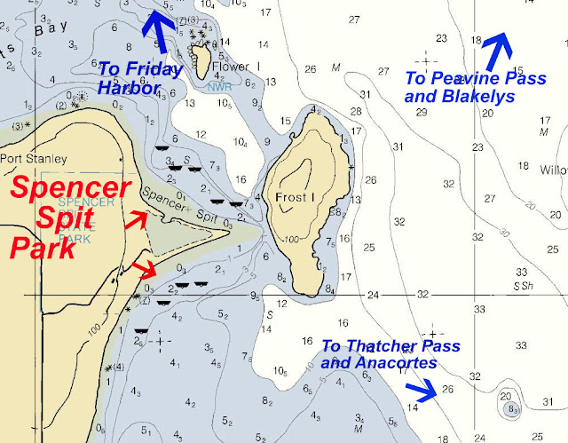
See the red dot in the image below? The red dot is where you want to bring your dinghy ashore to go to Lopez village. Within a block of landing is everything you want, (trinkets, sweets, restaurants, restroom with showers, major grocery store, museum, etc.) and I highly recommend you plan a day visit at the least, or spend the night anchored just inside the bay. You can anchor by the red dot but you will be rocked all night. Your choice! Or of course you can spend some boating units and tie up at one of the two marinas in the bay. BTW at low tide it gets pretty thin for a short stretch just inside the channel, pay close attention or get stuck.

Odlin County Park
Spencer Spit State Park
When navigating around the San Juans you will find yourself going past certain places again and again. For instance if your heading to Friday Harbor, Roche Harbor, Jones Island or over to Canada you will likely go around the North end of Lopez Island and quite possibly skipping distance from Spencer Spit Park and Odlin Park. And if you are like us, you prefer spending time and not money, so a handy place to anchor for free is appreciated, especially if its going to be dark in an hour or so. Odlin is very handy, as is Spencer Spit. Fisherman Bay is just a short hours run off the beaten path and may be your real ultimate destiny with creamy ice cream, nutty fudge or a tasty breakfast omelet waiting for you at Lopez Village.
Tip Avoid running around in the dark unless you know the area including the destination. An exception may be an experienced skipper and well found yacht going to a marina with lights and a slip waiting for you. Anchoring in the dark in an unfamiliar place while quite doable is no fun, leads to stressed out admirals and isn't part of a good plan.
 |

This is the beach on the north side of Spencer Spit where you will land your dinghy, that little building is a replica of the old Spencer cabin with a few historical signs you may look at. Frost Island is in the background. The campground is behind me about a quarter mile.
|
Fisherman Bay
 |
| Try clickng on pic to see if it gets bigger |
Lopez Village
See the red dot in the image below? The red dot is where you want to bring your dinghy ashore to go to Lopez village. Within a block of landing is everything you want, (trinkets, sweets, restaurants, restroom with showers, major grocery store, museum, etc.) and I highly recommend you plan a day visit at the least, or spend the night anchored just inside the bay. You can anchor by the red dot but you will be rocked all night. Your choice! Or of course you can spend some boating units and tie up at one of the two marinas in the bay. BTW at low tide it gets pretty thin for a short stretch just inside the channel, pay close attention or get stuck.

 |
| This easily spotted public stairway is where you access Lopez Village, just tie your painter to the steel stairway post This stairway is almost directly opposite the red dolphin nav. aid marking the spit and entrance to Fisherman Bay |
 |
| Here's the lonely float at Odlin County Park, sorry no overnights. Lopez village is too far to walk but an easy 20-30 minute bike ride. What we do is offload the bikes and then anchor as close as we want, then drag the dinghy up onto the float. This way were not hogging the dock, and our home sweet home is waiting for us when we get back dog tired. The parks four buoys are $10-$12. Just a short walk takes you to bathrooms and the campground. I say lonely because we never see many boaters here, probably because we rock and roll all night, but we never feel insecure at anchor like some places where we worry all night if we are dragging into someone.
Tip Odlin County Park would be an excellent place to meet up with friends that are car camping in the San Juans. Be sure to check on reservations for camping. In a pinch your friends could camp at Spencer spit, its just a short drive. I know your thinking why not meet at Spencer Spit State Park, you can except there's no dock there, but you have a dinghy so check on reservations at Spencer also. |

Chapter # 5
Sucia Island Group
Sucia, Echo Bay, Fossil Bay, Shallow Bay, Fox Cove, Ewing Cove, Snoring Bay, Matia, Patos, West Beach,
By now you may have figured that Islands and destinations are being grouped according to general area. The Sucia group is big and has more destinations than you can properly visit in one or even two cruises. Some people will make this area their destination for a week long cruise and not go to any others. Others like me will stop by one or two spots, spend a night or two and move on. Kayaks are useful all over the San Juans, but at Sucia you will be in kayak paradise.
Matia Island Matia is a close runner up for my favorite place. Matia and Jones are the two places we have hung out for extra days simply because we were enjoying ourselves so much. Rolfe Cove at Matia, once again not really a cove has a current at the float, but don't let that dissuade you, there are currents all over the place.

The float is small like at James holding only four medium size boats, on shore are two or three campsites and the standard com-posters. A few years ago they took out the fire pits and made all, of Matia campfire free. It was devastating news, but we got over it. Out in the non-cove are two anchor buoys, there is just a little bit of room close to the gravel beach to anchor, but all the way around on the other side of the island is a very protected cove with a view of Lummi where you will find peace and quiet. On shore at Matia is probably why we keep going back, there is an easy walking rain forest and shoreline trail unlike any other in the San Juans. Because Matia is so close to Sucia we will go there first and if there no room at the float or buoy, we run to Sucia, then come back later to try again.

By now you may have figured that Islands and destinations are being grouped according to general area. The Sucia group is big and has more destinations than you can properly visit in one or even two cruises. Some people will make this area their destination for a week long cruise and not go to any others. Others like me will stop by one or two spots, spend a night or two and move on. Kayaks are useful all over the San Juans, but at Sucia you will be in kayak paradise.
Tip Try to get to Sucia early, then you will have time to look around before settling down for the night, or just plan to move the boat the next day, once you have done some exploring.
- Sucia Island State Park
- Echo Bay
- Fossil Bay
- Shallow Bay
- Fox Cove
- Snoring Cove
- Ewing Cove
- Patos Island
- Matia Island
- West Beach Marina Resort
Echo Bay
Lets get right to it. Echo bay is huge but there is no dock or float, nada, none. They have lots of anchor buoys and something they call a linear float which is a heavy line strung between buoys that you tie to. The linear thing is ok, but a little weird and I guess it squeezes in a few more boats without them swinging. On shore, just a modest dinghy paddle away are trails leading to all the other bays. Also hidden in the woods is one of the famous composting facilities. Right on the beach at Echo Bay is a large group size fire ring for beach fires. (only one, so you may have some competition) The beach is great for dinghy landing at all tides. Echo Bay is where half the boaters will be. The rest will be at Fossil, and those that don't read this guide will be at Shallow.
Fossil Bay
This is where the floats are, two of them and both pretty big. Even though they can hold a lot of boats, don't count on there being room when you arrive, this place gets busy. Out a hundred feet or more are anchor buoys and lots of room for free anchoring. Just anchor and move over when someone leaves. Fossil Bay is also where the onshore campground is located. To make a reservation contact the Sucia Island State Park ranger directly by phone, not the online systems. The beach at Fossil Bay is not the beast dinghy beach due to mud flats at lower tides.
Fox Cove
Not really a cove, more like a channel created by a little island, so you will have current and mud beaches and not much room. However it is right off the beach from the campground so you may have a reason to anchor there.
Shallow Bay
This bay is known to be a rolly polly place to anchor, but there is quite a bit of room. The dinghy beach Is close to worthless at anything but high tide. On shore are some campsites (make arrangements by phone with ranger first) The famous China Caves are located in the cliff in the middle of the shoreline and are really worth exploring especially if you have athletic children, but you can always hike here from Echo or Fossil Bays.
Tip Anchor at Echo or use floats at Fossil Bay and walk 20-30 minutes over to China Caves. You don't need to motor into Shallow Bay and then slog through muck on a falling tide.
Snoring Cove and Ewing Bay
I'm combining these two and not saying anything because they are both just quiet places to anchor away from all the hustle of Echo and Fossil. The on shore trails are a little bit of a walk to, say China Caves but easy and mostly level.
West Beach
West beach Resort is on Orcas Island. They have a fuel dock and deli grocery at the top of the gang plank on shore. They also rent cabins and slips to overnight boaters or automoble travelers. West Beach is where you will make a beer and ice run if your at Sucia. West Beach is also where you will stop if your circling Orcas Island on your way from Bellingham to Roche or Jones or Stuart. And of course when traveling the other direction, once again West Beach is the only choice. Most of the time you should carry enough fuel and ice so you can go right on by but you need to know where it is.
Tip I suggest you make a point of visiting West Beach for waffle ice cream cones, then you will be familiar with it when it counts.
Patos Island You have to go to Patos, if for no other reason than its the most northern spot before you get into Canadian waters. There's no float but the bay (not really a bay) for anchoring is snug and mostly protected. You will have a short dinghy trip to an easy to use gravel beach. On shore is just a small handful of the usual tables, campsites, fire pits and bathroom. Patos is north of Sucia and many boaters quit at Echo Bay so there will be a lot less traffic, however its not all that big so your visit could go from loneliness to crowds on the same day. Out on the point about a ten minute walk is a picturesque lighthouse that is well worth the hike. You will be dealing with Georgia Strait currents out at Patos. (not in the bay) but around the area, so doing a little currents and tides homework may save you some time and fuel. Tip Read again the last sentence!
Matia Island Matia is a close runner up for my favorite place. Matia and Jones are the two places we have hung out for extra days simply because we were enjoying ourselves so much. Rolfe Cove at Matia, once again not really a cove has a current at the float, but don't let that dissuade you, there are currents all over the place.
The float is small like at James holding only four medium size boats, on shore are two or three campsites and the standard com-posters. A few years ago they took out the fire pits and made all, of Matia campfire free. It was devastating news, but we got over it. Out in the non-cove are two anchor buoys, there is just a little bit of room close to the gravel beach to anchor, but all the way around on the other side of the island is a very protected cove with a view of Lummi where you will find peace and quiet. On shore at Matia is probably why we keep going back, there is an easy walking rain forest and shoreline trail unlike any other in the San Juans. Because Matia is so close to Sucia we will go there first and if there no room at the float or buoy, we run to Sucia, then come back later to try again.

This image was taken from the picnic area on Matia
 |
| wow! minus tide at Matia |
Chapter # 6
The Rest of the San Juan area Destinations
This grouping of destinations includes important places it would take you years to discover. I strongly suggest you take advantage and include them in your knowledge base so that when the opportunity presents itself you will maximize your San Juan experience enjoying many cruises.
The San Juan Islands are considered the Islands of San Juan County, but much of the area you want to cruise is in Skagit County and Whatcum County. You can have a very successful outing and never enter San Juan County. Deception Pass is half in Island County and Skagit County so it's definitely not in the San Juans and yet must be included in your itinerary for the area or you have missed the boat.
More San Juan locations:
These places are not included with the previous groupings for one reason or another, but are every bit as important to you.
- James Island State Park
- Jones Island State Park
- Clark Island State Park
- Blakelys Marina / Store
- Stuart Island State Park
- Prevost Harbor
- Reid Harbor
Nearby San Juan area:
Lets face facts, you must drive through or near all these places on your way to Friday Harbor or Canada. Then on your way home you go the other way. The point I'm hammering is, don't miss em!
Lets face facts, you must drive through or near all these places on your way to Friday Harbor or Canada. Then on your way home you go the other way. The point I'm hammering is, don't miss em!
- Cypress Island
- Pelican Beach
- Eagle Harbor
- Cypress Head
- Washington Park (Anacortes city park)
- Saddlebag Island State Park
- Inati Bay
- Deception Pass State Park
- Cornet Bay
- Bowman Bay
- La Conner
- Squalicum Harbor
- Cap Sante
James Island State Park
If you wanted to make the claim of Sentinel to the San Juans, you could arguably give little James the title and then herald nearby Thatcher Pass as "Entrance to the San Juans" The satellite picture below shows how close James is to Thatcher Pass the main thoroughfare for those heading to the San Juans from Anacortes.
- James to Cap Sante in Anacortes is 9 nautical miles
- James to Friday Harbor is 12 nm
- James to Rosario is 10 nm
- James to Cornet Bay at Deception Pass is 10 nm.


Just like many Islands, James is all park with no inhabitants, its distinctive dog bone shape creates two bays. The west bay is well protected although sometimes currents will swing you at anchor. The east side is open to the wrath of Rosario. James has a smallish four boat float and wharf in the western bay and five or so anchor buoys on the east side. The beaches are dinghy friendly at all tide levels. On shore are three separate campgrounds, one designated just for kayaks. The sign says human powered vessels, but canoes and rowboats are simply not seen so kayaks is what they really mean. Fire pits, picnic tables, compost toilets, great shoreline and over the top hiking trails complete this wonderful park. James gives you a front row seat from the campground to view passing Orca pods if your lucky enough to be watching out towards Rosario Strait when they go by.

James is a good place to wait for conditions to improve on Rosario Strait, its also a great place to make your first landfall on day one.
Tip Slow down your schedule, don't go cruising with a plan to cover miles and miles of water. Experience shows that stress levels and resulting good times are inversely proportional to distance traveled. No that doesn't mean stay home.
Jones Island State Park
Jones Island is a wonderful place to take your family and enjoy boat camping. The islands unique proximity to the three major Marinas and harbors in the San Juans is a big plus, but even without these great nearby neighbors, Jones would still be your destination of choice.
A favorite starting point for kayaking is Deer Harbor, only 2 1/2 miles over usually calm water. Roche Harbor, a favorite resort and jump off point for those going to Canada is only 5 1/2 miles. Of course the San Juan's largest city and port is Friday Harbor, at only 5 3/4 miles distant.
A favorite starting point for kayaking is Deer Harbor, only 2 1/2 miles over usually calm water. Roche Harbor, a favorite resort and jump off point for those going to Canada is only 5 1/2 miles. Of course the San Juan's largest city and port is Friday Harbor, at only 5 3/4 miles distant.


All of Jones is a state park, the north cove is preferred by power boaters and sailors alike, inside you will find a protected bay with docks and anchor buoys, plus room to anchor if the buoys are in use.
 |
| North cove at Jones with new floats |
The North Cove is absolutely wonderful, There is a brand new dock, anchor buoys, a steep gravel beach (good for dinghy's), and room to anchor. The cove is protected from all but the worst north winds (very infrequent) On shore are lots of tent sites, each with picnic table and fire rings. There is a nice mowed lawn area for games and grazing deer. Bathrooms and running water are clean, cool, clear and convenient.
The island has several hiking trails, rated, easy and moderate. From the trails are magnificent views of the surrounding islands, and waters. Bring your camera to Jones, you will want to preserve the memories to show your friends that aren't as fortunate as you.
The friendly little deer are legendary on Jones, I say little because they are noticeably smaller than the deer on other islands. Some (not all) are quite tame, begging for handouts, allowing petting and ear rubs.
The other side of the island has more anchor buoys and campsites and is a favorite of nearby Deer Harbor kayaker's. Hiking trails circle the island and afford great views in all directions.
It's real easy to make Jones your destination and wile away the days, its close proximity to Deer Harbor make running for groceries easy.
 |
| Don't do this |
 |
| This deer was climbing table a minute later, much too forward and not afraid of fire either. |
 |
| Taxi service to shore at Jones, (dream on) Tip if you were thinking about not bringing a dinghy and counting on space at the float, you will be stuck on the boat at many locations. At the very least bring a $69 inflatable boat, you will be glad you did |

 |
| Someone donated a swing on south side |
 |
| Canada in far background, easy loop trail takes under an hour. |
Clark Island State Park
Clark is another of the drive by Islands on the way to somewhere else. My recommendation for Clark is to stop by for a quick lunch, then walk around the island for fifteen minutes, then move on. Clark is small and has a restroom and campsites but really not much going for it unless you need a place to camp or anchor and its getting dark. Clark's closer to Orcas than Lummi Island but being in Rosario Strait means wind and waves when the weather kicks up. I wouldn't want to be stuck on Clark in a storm.
Blakely's Marina and Store
Now here is a place you will really appreciate. A savvy cruiser will pick up on that last sentence.
Blakely Island is private and you wont be going anywhere outside the marina grounds. Our first experience purchasing fuel at the dock was interesting because there was no one around to tell us what to do. I asked an Indian fisherman before he pulled away from the float what the procedure was and he said, "Just put the gas in your boat and remember how much you get, then walk up to the store and tell them how much you got." That first purchase at Blakely's was fifteen gallons of gas, five huge ice cream cones and a bunch of Hershey bars. I think our last purchase left off the fuel.
Blakely's is located just inside Peavine Pass around the corner enough that when Rosario is throwing hissy fits, the float is calm and welcoming.
When you are heading from Anacortes to Friday Harbor or other places it is very convenient to swing in, and when the south end of Rosario is fogged in forcing you north around Cypress Island, again you will appreciate Blakely's central location.
Stuart Island State Park
Way over on the other side of Orcas and just a little north of Roche Harbor is where you will find Stuart Island, with turn point jutting out into Haro Strait marking the NW corner of Washington State. The island is mostly private property but the state maintains a park on an narrow isthmus between Prevost and Reid Harbors. The two anchorages although separate are joined at the hip.
Subscribe to:
Posts (Atom)